- Posts: 143
- Thank you received: 15

Mounting a chart or map so visible while paddling
5 years 6 months ago - 5 years 6 months ago #37742
by Arcturus
Replied by Arcturus on topic Mounting a chart or map so visible while paddling
Just thought of a very simple way to attach a chart to yourself, and it is quick-release, too.
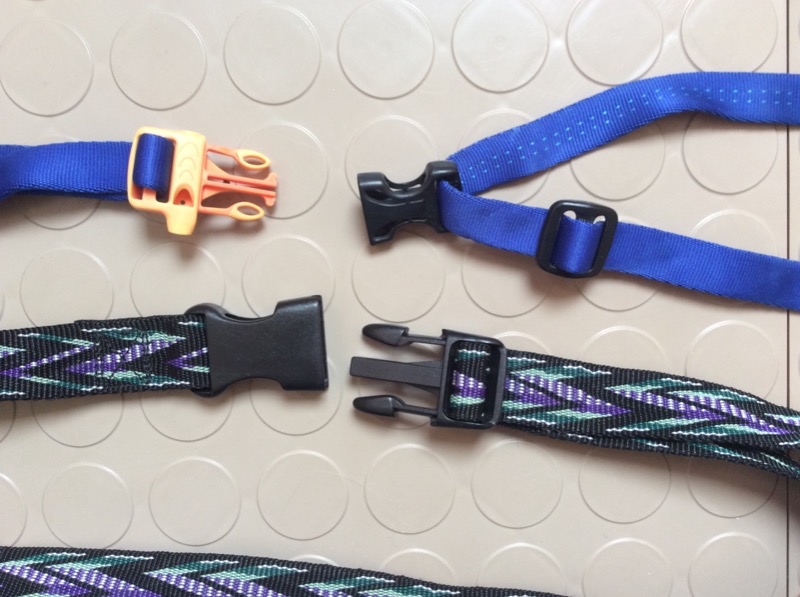
Get a nylon webbing strap the same dimensions as what you would use for a belt. Seal any cut ends with a match or over a gas range burner, then thread on a nylon/Delrin buckle set that pinches open and snaps shut. You do not need to sew these on. I made a cockpit cover retainer out of one such set that even was molded to incorporate a tiny pealess whistle in one end, plus two similar belts for wearing with pants.
REI and other hiking and climbing suppliers often have spools of this webbing in different widths, colors, and patterns. They also sell marine cord that has retroreflective stripes embedded in the main color (which is usually neon orange or black).
Depending on exactly which chart case you get, attach the case to the belt so it sits on your lap. If the case has corner grommets, run the marine cord through two of them and knot to your QR webbing belt. Done! You could put both a chart and some printed notes in the case: flip one way to see one and turn over to see the other.
In the photo below, the top belt requires no sewing at all.
The bottom belt comes presewn at one end, and you thread the other.
Attachments:
Last edit: 5 years 6 months ago by Arcturus.
Please Log in or Create an account to join the conversation.
5 years 6 months ago #37745
by mrcharly
Replied by mrcharly on topic Mounting a chart or map so visible while paddling
simple, obvious idea.
Using a QR buckle overcomes possible issues with it getting in the way when remounting.
Using a QR buckle overcomes possible issues with it getting in the way when remounting.
Please Log in or Create an account to join the conversation.
- LaPerouseBay
- Offline
- Platinum Member
Less
More
- Posts: 354
- Thank you received: 131
5 years 5 months ago #37928
by LaPerouseBay
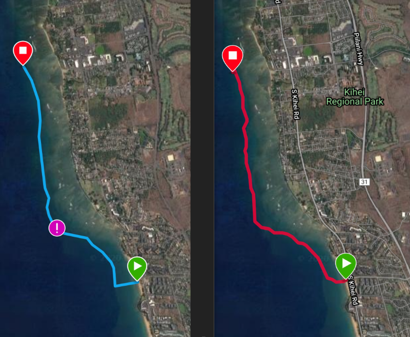
I finally got around to this. It works and is easy to set up on Garmin Connect. Like Zach says, mount the watch to your footstrap and follow the arrow. Easy and dead accurate. I tested it for the first time today. I'll do a route of the north shore, skirting the reef. I'll use it in good weather to get familiar with it. If a storm rolls in and obscures the reef or the harbor entrance, I'll be fine.
We had a storm roll thru Saturday and destroy a couple of skis. Freak storm, crazy powerful. Everybody is fine, just a bit wiser. I was onshore watching the carnage, I was too chicken to launch - watched a few guys get blown onto the rocks and called 911. Lifeguards snatched them out of a tight spot. The current was too strong to swim to safety...
Here's a video to get started on drawing a route. I don't use the phone, I'm desktop only with Garmin.
Attached is a side by side pic of the drawn path (blue) and the GPS of my line following the arrow. It was a side on wind, so I zigged around a bit. Easy peasy.
downwind dilettante
Replied by LaPerouseBay on topic Mounting a chart or map so visible while paddling
zachhandler wrote: Is there fog on the scottish coast? I imagine its a possibility. If there is suddenly zero visibility you could be in a really bad situation and a chart might not be much help. I recommend having some sort of gps watch on the footstrap, and knowing how to use it. In particular the feature that allows you to follow a “breadcrumb” trail such that you follow your exact course back home. If you follow a direct arrow that points home as the crow flies it might lead you into headlands reefs and other bad things.
I finally got around to this. It works and is easy to set up on Garmin Connect. Like Zach says, mount the watch to your footstrap and follow the arrow. Easy and dead accurate. I tested it for the first time today. I'll do a route of the north shore, skirting the reef. I'll use it in good weather to get familiar with it. If a storm rolls in and obscures the reef or the harbor entrance, I'll be fine.
We had a storm roll thru Saturday and destroy a couple of skis. Freak storm, crazy powerful. Everybody is fine, just a bit wiser. I was onshore watching the carnage, I was too chicken to launch - watched a few guys get blown onto the rocks and called 911. Lifeguards snatched them out of a tight spot. The current was too strong to swim to safety...
Here's a video to get started on drawing a route. I don't use the phone, I'm desktop only with Garmin.
Attached is a side by side pic of the drawn path (blue) and the GPS of my line following the arrow. It was a side on wind, so I zigged around a bit. Easy peasy.
downwind dilettante
Attachments:
Please Log in or Create an account to join the conversation.
Latest Forum Topics
-
- Keep Your Essentials Safe with the 10L Dry Bag by Harry Cooper
- 5 days 19 hours ago