- Posts: 415
- Thank you received: 44

Mounting a chart or map so visible while paddling
5 years 6 months ago #37681
by mrcharly
Mounting a chart or map so visible while paddling was created by mrcharly
Anyone have tips on how to mount a chart or map (e.g. ordnance survey map) so it is visible while paddling?
One issue that can occur when paddling a jagged coastline is that it is easy to lose track of your location, particularly if there are many small islands. An entry to a loch can be mistaken for a gap between islands (or visa-versa), leading to confusion about location.
An OS map (which shows land contours in detail) can be helpful on some coastlines, since you can use it to identify promontories (I am heading for promontory X, which is low-lying. On the way there I will pass Y, which has pronounced peak).
With my middle-aged eyesight, mounting such a map (or nav device) about at foot level is a good thing.
Please Log in or Create an account to join the conversation.
- sarzelopez
-
- Offline
- Senior Member
- Panamenian Paddler
5 years 6 months ago #37683
by sarzelopez
Replied by sarzelopez on topic Mounting a chart or map so visible while paddling
I suggest you plug your routes on a GPS watch, if it allows for navigation.
I've never used charts but imagine that even with the chart in front of you must be sure that your "reference peak" is in fact the one you are paddling by.
I've never used charts but imagine that even with the chart in front of you must be sure that your "reference peak" is in fact the one you are paddling by.
Please Log in or Create an account to join the conversation.
5 years 6 months ago #37690
by mrcharly
Replied by mrcharly on topic Mounting a chart or map so visible while paddling
Speaking from the point of view of someone who has done a bit of at-sea navigation (sailing and motor barge), it is the chart that helps you confirm the identity of coastal features, and hence your location.
Lighthouses, significant marks (ranging from port lights to postboxes), buoys; this is the sort of information I expect on a chart. I also expect to have the knowledge to read the chart.
I fail to see how a GPS watch is a better solution. If tide, wind cause you to need to change your route, what use are a few GPS waypoints?
Please Log in or Create an account to join the conversation.
5 years 6 months ago #37691
by Arcturus
Replied by Arcturus on topic Mounting a chart or map so visible while paddling
Charts are better for navigation on the water, for the reasons given above, They also are updated much more frequently. Terrestrial maps such as USGS topos do help in locating possible camping spots or fresh water sources.
Mrcharly, I don’t see how you can keep a chart close enough and useable in a surf ski cockpit. It’s easy with a decked kayak.
However, maybe you can keep a chart HANDY, which does not have to mean mounting iit to the ski. Attach it to yourself or your PFD. You’ll probably need to fold the chart and fit it inside a clear flexible chart case.
Please Log in or Create an account to join the conversation.
5 years 6 months ago #37693
by mrcharly
Replied by mrcharly on topic Mounting a chart or map so visible while paddling
Thanks, I was wondering about that - a map case that I can slip into my PFD front pocket might work well.
Before a big trip, maybe writing nav notes (tidal stream times and directions, notable tidal overfalls, navigation waypoints, that sort of thing) into a small page and strapping that to a thigh or similar.
Before a big trip, maybe writing nav notes (tidal stream times and directions, notable tidal overfalls, navigation waypoints, that sort of thing) into a small page and strapping that to a thigh or similar.
Please Log in or Create an account to join the conversation.
5 years 6 months ago - 5 years 6 months ago #37694
by Arcturus
Replied by Arcturus on topic Mounting a chart or map so visible while paddling
A china marker writes on surfaces that get wet and stays legible. The marks are removable without any special substances. One well-known sea kayak coach and expeditionist advocated writing right on the deck’s gelcoat surface. It works,
You might be able to roll up the encased chart (some cases are more flexible than others), rubber band it to stay rolled, and then tether from one or two grommeted corners that they usually come with. Attach the tether to a carabiner to somewhere on your PFD or clothing.
You could also roll a waterproof chart directly inside a small-diameter polyethylene tube with caps, similar to PVC pipe but much lighter and more UV-resistant. Then tether that. IIt’s not instantly useable but could be good for storage between outings,
Have fun!
Last edit: 5 years 6 months ago by Arcturus.
Please Log in or Create an account to join the conversation.
- zachhandler
-

- Offline
- Platinum Member
Less
More
- Posts: 820
- Thank you received: 203
5 years 6 months ago #37695
by zachhandler
Current Skis: Nelo Vanquish AIR, Epic V10g4, NK 670 double, Epic v8 double g2, Think ion g3, NK exrcize, Carbonology Feather, Think Jet, Knysna Sonic X
Former Skis: Epic v10g3, Kai Waa Vega, Epic V12 g2, Epic V12 g1, Epic v10 double, Nelo 550 g2, Fenn Elite S, Custom Kayaks Synergy
Replied by zachhandler on topic Mounting a chart or map so visible while paddling
Is there fog on the scottish coast? I imagine its a possibility. If there is suddenly zero visibility you could be in a really bad situation and a chart might not be much help. I recommend having some sort of gps watch on the footstrap, and knowing how to use it. In particular the feature that allows you to follow a “breadcrumb” trail such that you follow your exact course back home. If you follow a direct arrow that points home as the crow flies it might lead you into headlands reefs and other bad things.
Current Skis: Nelo Vanquish AIR, Epic V10g4, NK 670 double, Epic v8 double g2, Think ion g3, NK exrcize, Carbonology Feather, Think Jet, Knysna Sonic X
Former Skis: Epic v10g3, Kai Waa Vega, Epic V12 g2, Epic V12 g1, Epic v10 double, Nelo 550 g2, Fenn Elite S, Custom Kayaks Synergy
Please Log in or Create an account to join the conversation.
5 years 6 months ago - 5 years 6 months ago #37698
by waverider
Replied by waverider on topic Mounting a chart or map so visible while paddling
Coming from a kayak fishing background we use navionics, gps maps, obviously the integral version with sounder is a no go as it requires batteries etc, but there is also the mobile ap version. You would have to set it to sleep mode so it only fires up when you want to look at it, or the ap chews through phone battery. I would suggest using a separate phone for this reason. the phone ap has a positioning curser, and can plot path if required. Different map overlays possible, showing terrain etc.
Really wouldnt be hard to have an extended mounting bracket from either forward bulkhead of behind foot board, to mount something within reach other than using footstrap
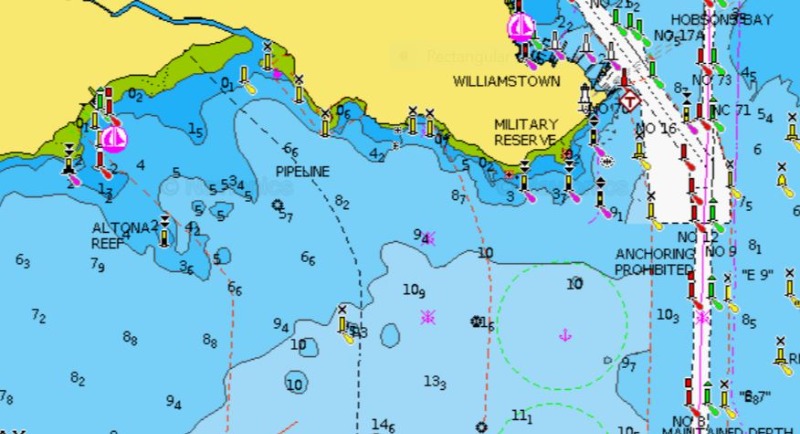
kayak fishos regularly rely on this ap to navigate around in the dark when they cant see any landmarks at all. Definitely get you home in a fog
Really wouldnt be hard to have an extended mounting bracket from either forward bulkhead of behind foot board, to mount something within reach other than using footstrap
kayak fishos regularly rely on this ap to navigate around in the dark when they cant see any landmarks at all. Definitely get you home in a fog
Attachments:
Last edit: 5 years 6 months ago by waverider.
Please Log in or Create an account to join the conversation.
5 years 6 months ago #37699
by waverider
Replied by waverider on topic Mounting a chart or map so visible while paddling
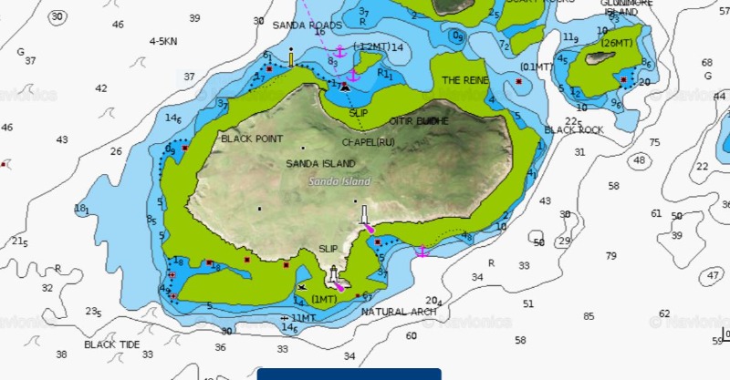
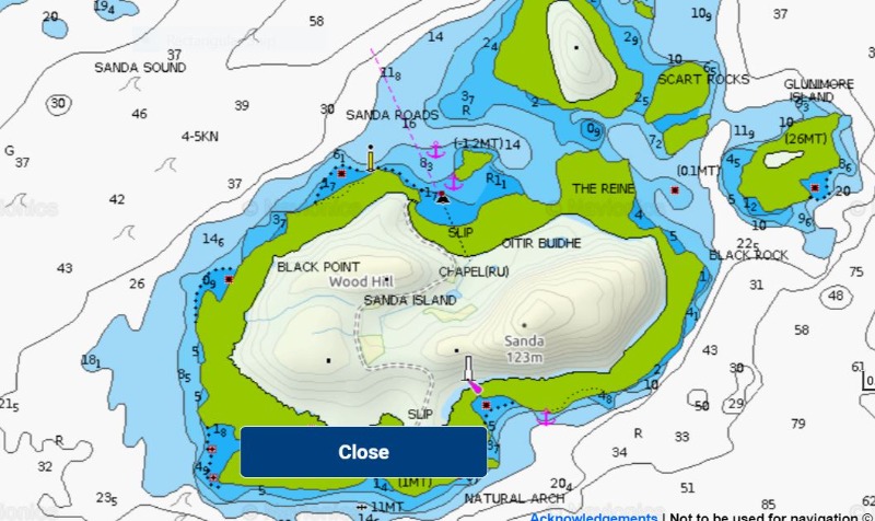
terrain view and satellite views
Attachments:
Please Log in or Create an account to join the conversation.
- LaPerouseBay
- Offline
- Platinum Member
Less
More
- Posts: 354
- Thank you received: 131
5 years 6 months ago - 5 years 6 months ago #37700
by LaPerouseBay
downwind dilettante
Replied by LaPerouseBay on topic Mounting a chart or map so visible while paddling
I had a look around the web when this thread started. I agree with the Navionics suggestion.
If you add a bluetooth GPS antenna and link it to the phone, it will save your battery.
Personally, I'd never venture out in the north Atlantic without an experienced guide and every possible backup system known to man.
I may try the Navionics app. It's only $14.99 for the U.S. maps.
I hate it when the entrance to the harbor is obscured. This time of year can be treacherous on the north shore in low visibility. Squalls come thru, rogue sets across the reef, etc. The glare of the sun this time of year is a big pain in my ass.
I've been charting my runs for many years on Maui's north shore thru Google Earth - to help educate myself on the depths at certain landmarks. Sometimes those landmarks go away. To have a backup of my location is something I've wanted many times. Those maps are very, very nice. Very user friendly and flexible.
downwind dilettante
Last edit: 5 years 6 months ago by LaPerouseBay.
Please Log in or Create an account to join the conversation.
5 years 6 months ago #37701
by mrcharly
Replied by mrcharly on topic Mounting a chart or map so visible while paddling
I like the idea of writing on the deck (or on the hump).
The Nelo has a bracket on the footstrap, mainly aimed at mounting cameras. I have a map holder for cycling and might see if that will fit on the footrest bracket.
The Nelo has a bracket on the footstrap, mainly aimed at mounting cameras. I have a map holder for cycling and might see if that will fit on the footrest bracket.
Please Log in or Create an account to join the conversation.
5 years 6 months ago #37702
by ggc
Replied by ggc on topic Mounting a chart or map so visible while paddling
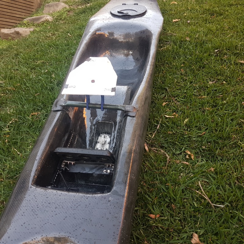
Did something similar for an adventure this year, hopefully the photo uploads, it makes more sense than my description.
Older model Miry mtb map board with a piece of coreflute cutdown to a smaller size.
Thought about using a cutdown carbon handlebar to mount it to, but ended up putting a carbon sleeve over some plastic conduit.
Step 1: Essentially you're making a carbon tube with flat ends. .
Cut the conduit just wide enough to sit on the top of the footwell, squash the ends of the conduit flat with a heat gun + a vise, then wet out the carbon sleeve and vac or heatshrink it over the plastic conduit.
Step 2: Make some L brackets that are custom shaped to fit the footwell
Cover the sides and top of the footwell with plastic and layup up some carbon strips to make a "L bracket" that goes up the side of the footwell and over the top edge.
Step 3: Join the L brackets to the carbon tube
With the brackets still sitting in place on the boat, go crazy with some scrap bits of carbon and join the L brackets and the carbon tube. Once it's all cured, add some decent quality velcro to the back of the brackets and the footwell to add a bit more security.
Please Log in or Create an account to join the conversation.
5 years 6 months ago #37703
by Ronbo
Replied by Ronbo on topic Mounting a chart or map so visible while paddling
If you can fit it to an A4 sheet, try taping it to the hump under your knees. Only one page would be accessible, but it's close enough to read easily.
Please Log in or Create an account to join the conversation.
5 years 6 months ago #37704
by Arcturus
Replied by Arcturus on topic Mounting a chart or map so visible while paddling
The belt-and-suspenders approach would be good for some places such as Scotland, Maine coast, NW WA...but remember also that (a) you’ll probably use what you are familiar with more often than the other way, and (b) mariners were navigating in all kinds of conditions in unknown areas, for centuries. There are methods for relying only on chart and compass in peasoup fog. Oldtimers sometimes crashed into obstacles or got off course, but so do those today who rely solely on GPS.
You still have to observe what’s around you and use common sense 100% of the time, no matter what device(s) you have.
Make sure any battery-powered device is fully charged. Know what the tidal currents will be doing if you paddle in areas strongly affected by those.
And, although this does not seem to be done by ski paddlers, you may want to carry a spare paddle on some outings, or use something other than the lightest paddle you own.
Please Log in or Create an account to join the conversation.
- Greg Miller
- Visitor
5 years 6 months ago #37708
by Greg Miller
Replied by Greg Miller on topic Mounting a chart or map so visible while paddling
I like Selkie's suggestion (on other forum) of having the Phone/GPS thigh mounted (with velcro or running strap. Easier to see (for us getting on in years) and easily assessed if you want to alter views or different screens.
One to try I think.
One to try I think.
Please Log in or Create an account to join the conversation.
- sarzelopez
-
- Offline
- Senior Member
- Panamenian Paddler
5 years 6 months ago - 5 years 6 months ago #37710
by sarzelopez
Replied by sarzelopez on topic Mounting a chart or map so visible while paddling
Sorry, I didn't mean GPS waypoints, but the literal route/possible routes.
Tides are regular, so I just always know where im at tide-wise.
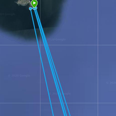
I only do 3 routes where the wind could change my landing spot or route. 1 of which is the long off shore one where you can't see anything but water until after about 16kms.
This is how I saw routes on my suunto.
You can change the scale, I used 200m instead of 10km
If no matter what happened I was landing at point X, I just drew that route and followed the path. I can't see any way this can go wrong. The chart would be usefull for drawing the route on the PC going around the sandbars, lighthouses etc. The way I did, I YOLO'd the route on a super low tide, so I could see everything and then drew that one.
Another scenario is where you take off from one place and depending on the conditions you might want to change your landing spot. In my case for this 20km run, I am familiar with 3 beaches in between the real destination, so I draw the route to the 4 possible landing points on the same course,I start on the real route (farthest from the shore) and if I want to fold, I just jump to another line. Again, I have it plugged as if it was one big 90km or whatever route, with the lines branching out from the starting point.
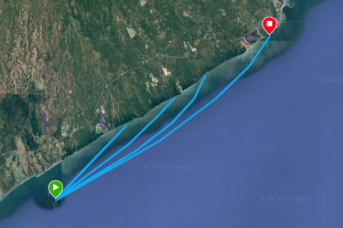
The last scenario is for the off shore, where the landing spot is the same but depending on the wind you can take about 3 different lines. Again, I put the 3 lines in the same "course" and depending on the forecast 15 minutes before the start, I know which one to follow. If I'm taking the one in the center but the waves/wind sart coming in strong form my left, I can either adjust or completely jump to another line.
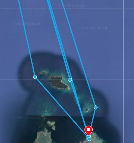
PD. This are training/race route planning, I guess some similar planning can be done for expeditions, sightseeing, touring.
Quick Edit: the best scale is 200m
Tides are regular, so I just always know where im at tide-wise.
I only do 3 routes where the wind could change my landing spot or route. 1 of which is the long off shore one where you can't see anything but water until after about 16kms.
This is how I saw routes on my suunto.
You can change the scale, I used 200m instead of 10km
If no matter what happened I was landing at point X, I just drew that route and followed the path. I can't see any way this can go wrong. The chart would be usefull for drawing the route on the PC going around the sandbars, lighthouses etc. The way I did, I YOLO'd the route on a super low tide, so I could see everything and then drew that one.
Another scenario is where you take off from one place and depending on the conditions you might want to change your landing spot. In my case for this 20km run, I am familiar with 3 beaches in between the real destination, so I draw the route to the 4 possible landing points on the same course,I start on the real route (farthest from the shore) and if I want to fold, I just jump to another line. Again, I have it plugged as if it was one big 90km or whatever route, with the lines branching out from the starting point.
The last scenario is for the off shore, where the landing spot is the same but depending on the wind you can take about 3 different lines. Again, I put the 3 lines in the same "course" and depending on the forecast 15 minutes before the start, I know which one to follow. If I'm taking the one in the center but the waves/wind sart coming in strong form my left, I can either adjust or completely jump to another line.
PD. This are training/race route planning, I guess some similar planning can be done for expeditions, sightseeing, touring.
Quick Edit: the best scale is 200m
Attachments:
Last edit: 5 years 6 months ago by sarzelopez.
Please Log in or Create an account to join the conversation.
- SpaceSputnik
- Offline
- Platinum Member
Less
More
- Posts: 526
- Thank you received: 42
5 years 6 months ago #37724
by SpaceSputnik
Replied by SpaceSputnik on topic Mounting a chart or map so visible while paddling
In my humble opinion, mounting a useable nav aid on a ski in a useable manner is quite difficult. For me nav screens at the foot strap are not a good option. Too far to see and almost impossible to operate.
FSKs such as Epic 18x are much more livable in long haul scenarios. You can mount all sorts of stuff on it and reach it too. You can also strap a map to your spray skirt.
FSKs such as Epic 18x are much more livable in long haul scenarios. You can mount all sorts of stuff on it and reach it too. You can also strap a map to your spray skirt.
Please Log in or Create an account to join the conversation.
- Epicpaddler
-
- Offline
- Elite Member
Less
More
- Posts: 261
- Thank you received: 33
5 years 6 months ago #37736
by Epicpaddler
Replied by Epicpaddler on topic Mounting a chart or map so visible while paddling
Improvise, adapt, overcome.
I agree that a sea kayak is way more user friendly when I comes to mounting/reading charts. I tried taping a map of a racecourse on the deck of my surfski one time for a long race. Besides not being able to see it well, it quickly got water spots all over the waterproof cover and I couldn't read it. I'm a tech nerd, but I haven't had the best experience relying on electronics when in a saltwater environment. I'm sure you could find a way to mount/strap/ a chart to your thigh. Necessity is the mother of invention. Let us know what kind of solution you come up with. i'd love to see it.
I agree that a sea kayak is way more user friendly when I comes to mounting/reading charts. I tried taping a map of a racecourse on the deck of my surfski one time for a long race. Besides not being able to see it well, it quickly got water spots all over the waterproof cover and I couldn't read it. I'm a tech nerd, but I haven't had the best experience relying on electronics when in a saltwater environment. I'm sure you could find a way to mount/strap/ a chart to your thigh. Necessity is the mother of invention. Let us know what kind of solution you come up with. i'd love to see it.
Please Log in or Create an account to join the conversation.
- zachhandler
-
- Offline
- Platinum Member
Less
More
- Posts: 820
- Thank you received: 203
5 years 6 months ago #37739
by zachhandler
Current Skis: Nelo Vanquish AIR, Epic V10g4, NK 670 double, Epic v8 double g2, Think ion g3, NK exrcize, Carbonology Feather, Think Jet, Knysna Sonic X
Former Skis: Epic v10g3, Kai Waa Vega, Epic V12 g2, Epic V12 g1, Epic v10 double, Nelo 550 g2, Fenn Elite S, Custom Kayaks Synergy
Replied by zachhandler on topic Mounting a chart or map so visible while paddling
Do you really need a chart? How long do you plan on being out there? I could see charts being a big deal on multi day expeditions where you are navigating unknown waters day after day. But if you are just based in one location you might be able to just gradually expand the distance you venture and get familiar with the area that way. Don’t be intimidated by GPS. All ski paddlers I know paddle with one on their footstrap. Most dont use the navigation arrow feature but it is actually simple and effective. I use it pretty much every time I downwind. It is easy to learn and works very well.
Current Skis: Nelo Vanquish AIR, Epic V10g4, NK 670 double, Epic v8 double g2, Think ion g3, NK exrcize, Carbonology Feather, Think Jet, Knysna Sonic X
Former Skis: Epic v10g3, Kai Waa Vega, Epic V12 g2, Epic V12 g1, Epic v10 double, Nelo 550 g2, Fenn Elite S, Custom Kayaks Synergy
Please Log in or Create an account to join the conversation.
- ccchappell
-

- Offline
- Senior Member
Less
More
- Posts: 69
- Thank you received: 26
5 years 6 months ago #37740
by ccchappell
BracaSport USA Importer
FastPaddler.com
Replied by ccchappell on topic Mounting a chart or map so visible while paddling
Like Zach says, a GPS in Navigation mode with arrow and waypoints works great. Here's a picture of a set up I used years ago for a foggy Blackburn Challenge (20 miles around Cape Ann). I made a simple bracket from a piece of aluminum, bolted to footplate then mounted a small held Garmin. Then had my Garmin 310 on the foot strap for typical metrics. Downloaded the route to the hand held, put in navigation mode and watched the arrow point to the next waypoint. Really like having the two separate functions. Once I started them didn't have to touch. I know this doesn't give a map or chart, but agree the Nav function is great.
Chris
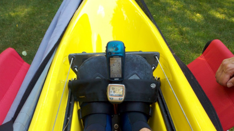
Chris
BracaSport USA Importer
FastPaddler.com
Attachments:
Please Log in or Create an account to join the conversation.
Latest Forum Topics
-
- Keep Your Essentials Safe with the 10L Dry Bag by Harry Cooper
- 5 days 18 hours ago